Spanning a river in a steep-sided ravine, the bridge which we were asked to investigate rests on four piers, the highest reaching 52 m. While two piers stand on the main rocky bed of the river, the other two rest on the flanks of the ravine. One of these had already been reinforced during earlier works.
| En partenariat avec le Cabinet Christian Haller, ingénieur géomètre officiel, à Genève. |
The side of the ravine on which TPLM-3D was to work showed signs of major erosion since the original construction of the bridge. The stability of the whole structure was potentially affected. Our surveys were therefore required to:
A precise survey network was established, based on the two central piers which were considered to be stable. The initial situation and the subsequent surveys are all referred to this network.
By surveying a point every 3 cm, the geometry of the cliff was described in full detail. Our task was to generate a digital model which would faithfully represent the present reality, especially regarding geological faults and other significant structures in the cliff This model is a triangular irregular network (TIN or mesh) optimised with regard to the number of points in the raw point cloud as captured (5 million to generate a mesh of 170 000 triangles). Only salient points are retained for the generation of the model; this process enables the file sizes to be substantially reduced without detracting from the accuracy or the density of the original data.
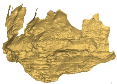
The TIN then serves as the basis for volume calculations, for the automatic extraction of a series of closely spaced profiles and for the creation of the orthophoto.
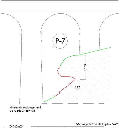
The closely spaced sections and profiles enable the dangerous areas to be viewed and quantified, especially the bottom of the overhang which is less than 3 m from the pier.
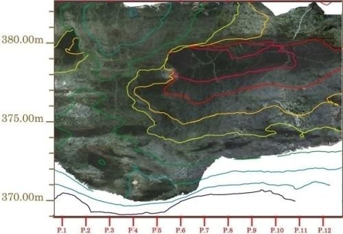
In order to localise the main weaknesses and those parts of the cliff which are subject to erosion, the client requested an orthophoto of the cliff. This document can be integrated with a plot of the elevation of the cliff at the same scale.
Six photogrammetric images, combined with the high density TIN, enable a very detailed orthophoto to be produced. One pixel in the image corresponds to 1 cm in the object. The detail thus appears at the correct scale and perfectly spatially referenced.
The process of conversion of the point cloud into the TIN requires considerable expertise, if an accurate and reliable image is to be supplied. The same applies to the profiles, the volume calculations and the computation of a high definition orthophoto.
 |
 |
Contact
Follow us
|
|
ZA Champ du roy. 219 chem. des goules 38670 Chasse-sur-rhône |