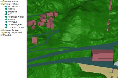
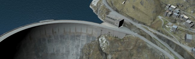
The Tignes (Chevril) dam was the highest arch dam in Europe at the time of its completion in 1952. Its catchment area covers 171 km2 and the Chevril reservoir holds up to 235 million m3 of water. Over its lifetime the dam has been equipped with a variety of monitoring devices (pendulums, piezometers, flow meters, etc.). These are distributed both inside and outside the dam and also on the natural terrain downstream.
The dam has never undergone a systematic survey, which presents a problem for its owner, Electricité de France (EDF), which only possesses old paper plans, some of them annotated to show instruments added at different times. Thus TPLM-3D was commissioned to provide an exhaustive and accurate survey of the whole dam and its surrounding area of natural terrain.
Our work took place in three stages :
– A helicopter-borne laser scanner survey was performed by one of our partners, a company specialising in such work. The long-range laser scanner is linked with an inertial system and differential GPS, so as to provide, after processing, point clouds with an accuracy of 10 cm. TPLM-3D then further processed these point clouds to create a digital terrain model for the dam and its surroundings. We paid particular attention to the ease of handling of the model by splitting the buildings, roads, natural terrain, etc. into separate layers. The 3D topology also received special attention.
– A terrestrial laser scanner survey was carried out by ourselves. The very enclosed areas of the Isère gorge just below the dam, inaccessible to helicopters, were scanned using a Leica Geosystems ScanStation 2. This technique provides sub-centimetre measuring accuracy over a range of up to 180 m. These surveys were used to complete the digital model generated from the helicopter-borne data.
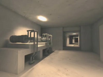
– A terrestrial laser scanner survey combined with total station observations was carried out for the whole interior of the dam, including the galleries created during construction by diversion (through tunnels) of the old Val d’Isère and Isère roads. The pendulums, piezometers, pumps and cabinets containing electrical equipment were all accurately surveyed in order to integrate them into the overall survey.
 |
 |
In general terms, a positioning accuracy of the order of 2 cm was achieved inside the dam, with 5 cm for the external structures and 10 cm on the natural terrain.
Contact
Follow us
|
|
ZA Champ du roy. 219 chem. des goules 38670 Chasse-sur-rhône |