The Gier Roman Aqueduct dates from the 1st century AD. Drawing on the waters of the River Gier from Saint-Chamond in the Loire département, the aqueduct contributed to the water supply of the city of Lugdunum (modern Lyons). Classified as a historic monument in 1912, it now requires renovation in order to continue to satisfy the demands of tourists as well as heritage enthusiasts and professionals.
The existing plans of the aqueduct are old; they do not reflect the deterioration of the structure and provide no help in carrying out the necessary conservation work. To consolidate the monument and its architecture, new plans which are both accurate and up-to-date are required.
Because the required timescale was very short, it was not feasible to supply a stone-by-stone plot of the monument and of its condition. We therefore proposed a very high resolution orthophoto for the whole 650 metre section (1 pixel on the orthophoto corresponding to 5 mm on the aqueduct).
Production of an orthophoto of a structure of this kind involves three steps :
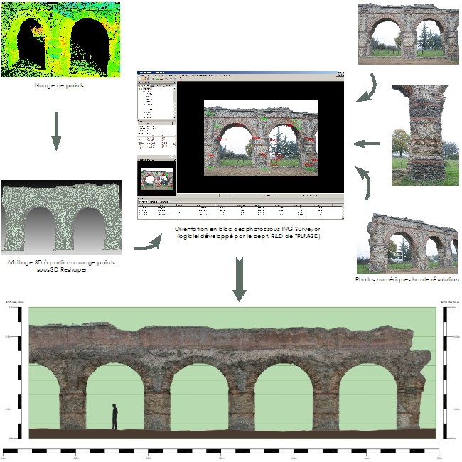
Degraded areas, surface differences … by providing far greater detail than a traditional drawing, this method enabled us to produce a high quality product within the timescale required.
Contact
Follow us
|
|
ZA Champ du roy. 219 chem. des goules 38670 Chasse-sur-rhône |